


Map Tailoring
Currently the presentation of the maps and tables are tailored towards the author's current airline. This tailoring is reflected by the coloured boxes on the maps, and part of the contents of the tables.
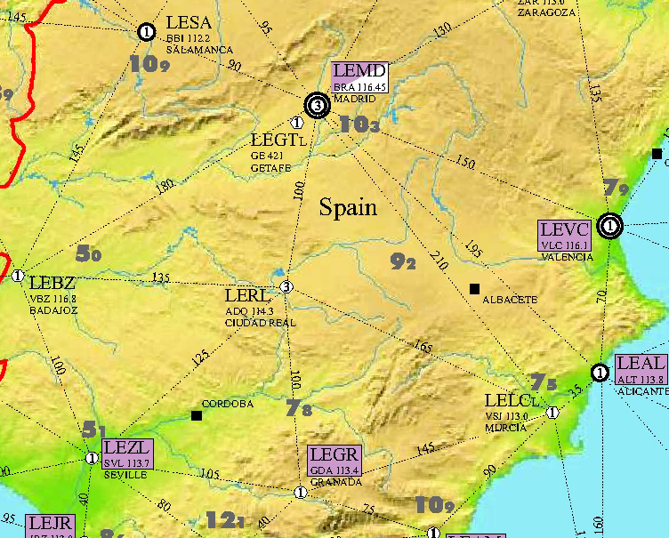
Maps in more detail
The boxes around the ICAO label indicate the presence of specific airport approach charts on the aircraft. This implies a preference towards these airports as alternates from the airline management. This is, perhaps, a little distracting to pilots of other companies. These coloured boxes on the charts exist as an overlay and can easily be removed or substituted.
The map below shows a section of the Spanish map as it currently exists. Clicking on each of the three buttons below will cycle the image between the original author tailored map, the raw map without boxes, and the map tailored towards Easyjet.
| original tailored map | raw map without tailoring | easyjet tailored map |
|---|
Tables in more detail
The tables currently show a mixture of general airport data and author specific data. The list below shows all of the fields that are currently populated in the database, and whether they are currently displayed in the maps or tables.
| Field | Expanded Description | In use ? |
|---|---|---|
| Airport Name | Table | |
| Alternate Name | Used for non-latin alphabetic versions, eg. Москва (Moscow) | No |
| ICAO Code | Four letter code, first two letters of which indicate the country | Map and Table |
| IATA Code | Three letter code. | No |
| Country | Russia and China are split into Domestic and International | Map |
| Airport Type | Civil, Military or Joint use | Map |
| Co-ordinates | Latitude and Longitude in degrees and minutes. Also available in degrees only to 2 decimal places | No |
| Elevation | Airfield elevation in feet (metres also available) | No |
| Google Earth | The year of the current Google Earth image | No |
| Operating Hours | H24 or not | Map |
| RFF Category | Rescue and Fire Fighting Category, and in its absence, ICAO airport code if known. | Table |
| Jet Fuel Availability | Availability of Jet A-1, Jet A (USA) or TC1 (Russia) | Table |
| Customs Availability | Check Box denoting international status of airport | Table |
| Airfield Beacon | On or near airport beacon, with preference given to VOR/DME | Map |
| ATIS Frequency | Table | |
| One World Destination | If a One World Alliance airline operates to this airport it is shown here | Table |
| Runway Designator (Width) | If no width is shown, the runway width is at least 45m | Table |
| Best Approach Type | Best approach based on visibility requirement to each end of runway | Table |
| Landing Distance | Landing Distance from each threshold point to end of runway | Table |
| Bearing Strength | Data held as PCN/LCN/ISWL/AUW etc. This is then converted to a figure in tonnes for each required aircraft type | Table |
It is possible to add other operator criteria to the database, for example Star Alliance visitors could replace the current One World visitors column.
Download Page
Once tailored maps exist, these would then be available to download from this site on a dedicated download page, only accessible to registered users with a specific access level.
Cost
The cost of map tailoring depends upon the amount of work required - please email for a quotation.